Home Page | My Works | Seminar | BURP Thesis | Contents
|
CHAPTER THREE
STUDY AREA
Khulna City is located on the banks of the Rupsha and the Bhairab river. It lies between 22047´16´´ to 22052´ north latitude and 89031´36´´ to 89034´35´´ east longitude. The city covers an area of 45.65 square kilometers with a population of near about 1 million. The city is 4 m above the mean sea level (MSL). Khulna is bounded by the Bhairab River and Fultala Thana on the north, by the Rupsha River on the east and south and on the west by Dumuria Thana. The location of the study area is shown on Map 3.1.
Khulna Municipality was established in 1884 during the British colonial regime. The area within which municipal limits was 12.02 square kilometers. Khulna City has a long history. Between 1884 and 1947, it had a long journey with little prospects for growth. In 1947, a large number of Muslims from India had migrated to the then East Pakistan and many of them settled in Khulna. The impact of such migration was revealed in 1951 census, when Khulna population rose to about 42,000, nearly four times than it had just 5 years ago (KDA, 1998).
During late 1950s, and early 1960s Khulna became an important centre for industrial development. With the establishment of a second seaport of the country at Mongla, just about 20 miles south of Khulna town, the city gained further momentum. Many new industries were setup at Khulna and commercial activities increased manifolds, and thus, the city became centre point of jute industries and jute trade in Bangladesh.
After liberation of Bangladesh in 1971, the population of Khulna continued to rise, but the industrial sector did not take place with its population growth. In fact, after 1968, the industrialization almost stopped and the huge labor force in the city was forced to seek alternative employment elsewhere. The city experienced a declining trend until the 1990s, when the economy started to revive again based mainly on shrimp farming and processing activities and the activities related to the establishment and development of a new University in Khulna (KDA, 1998).

Modern Khulna with industrial development is comparatively a new city although it has a long history of development. Situated on the river Rupsha and Bhairab, traditional Khulna town was known as a river port cum fishing centre since ancient times. However, with the modern industrialization Khulna held a unique position in the deltaic region of the Ganges and began to expand as economically a vibrant metropolis. The city suffered a set back with diminishing industrial activities. Nevertheless, it seems that an economic regeneration is taking place in the city based on business and fishing activities.
Khulna attained the status of a metropolitan city (population more then 1 million) in 1984 through the Khulna Municipal Corporation Ordinance of 1984 (though in reality the population of Khulna was not 1 million) and then in 1990 it was declared as a City Corporation by virtue of a bill passed by the Jatiya Sangsad (National Assembly).
Population growth of Khulna City took place in several phases. The first growth came from the extension of railway line from Jessore to Khulna during the British period. In the second phase, division of India played a vital role in population growth through the in flex of refugees. In the third phase, industrialization of Khulna in the 1960s played a remarkable role. During the post Liberation period, the population of Khulna City was observed a tremendous growth. This was mainly due to rural urban migration and natural increase of population. Together they contributed to increase of 4.13 percent per year. It can be observed that migration from other places to Khulna had been the dominant factor of population growth. Figure 3.1 shows the trends in population growth during last 100 years.
Figure 3.1: Population of Khulna Municipality/KCC Area 1901-1991

Source: Draft Final Report Vol. II: Preparation of Structure Plan, Master Plan and Detailed Area Plan for Khulna City.
Population Growth
The review of past census data of Khulna City reveals that there has been a steady growth of population between 1901 to 1961. A sharp rise in population was observed in 1974. Over a period of about 13 years population of the city marked an increase of about 445 per cent (URDP, 1999). The sudden rise in population attributed mainly by the socio-political change in country following the War of Liberation. Table 3.1 shows the chronology of population growth in Khulna City since 1901.
Table 3.1: Population Growth in Khulna City, 1901 - 1998
|
Year |
Population (in 000) |
Growth Rate Per cent /Year |
|
1901 |
10.43 |
- |
|
1911 |
18.17 |
5.55 |
|
1921 |
23.50 |
2.57 |
|
1931 |
28.00 |
1.75 |
|
1941 |
34.00 |
1.94 |
|
1951 |
42.00 |
2.17 |
|
1961 |
80.22 |
6.42 |
|
1974* |
437.30 |
13.04 |
|
1984 |
561.95 |
3.58 |
|
1991 |
663.34 |
1.66 |
|
1998 |
847.58** |
3.50 |
* The census of 1971 could not be held because of the War of Liberation.
** Estimated by the Khulna City Master Plan Project.
Source: District Documents Census Documents, 1901- 1991, BBS.
Population Density and Distribution
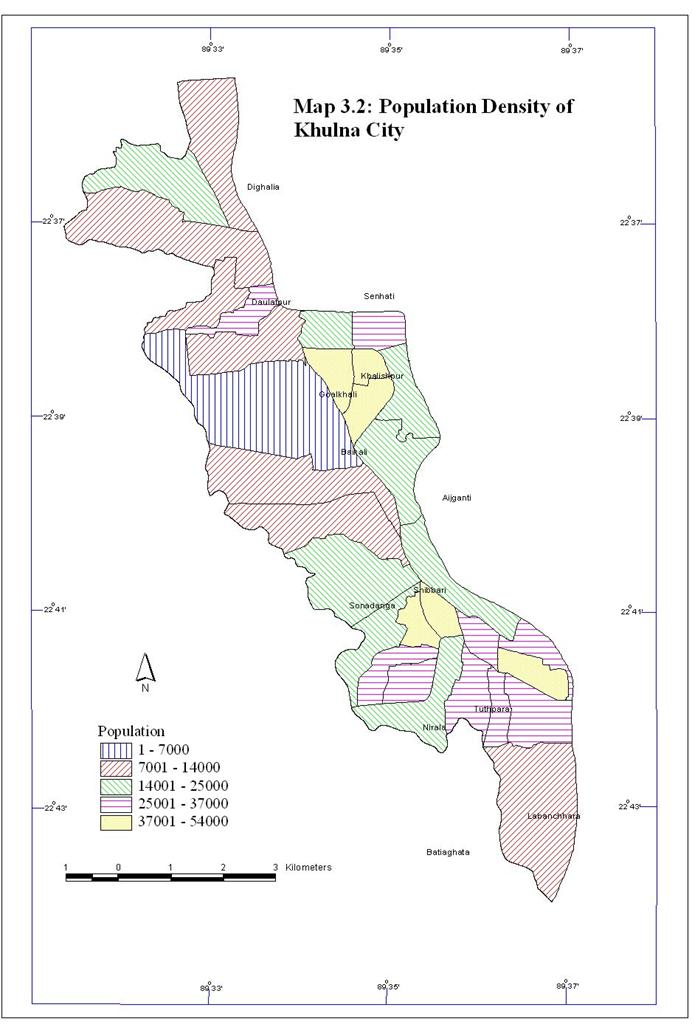
The present average density (1998) of population of Khulna City stands at 17,735 persons per sq. km. The highest density wards are 10, 11, 12 and 20 where density varies between 45,152 to 53,335 persons per sq. km. Wards No. 3 and 9 are the areas of the lowest density wards where density varies between 5934 to 7005 persons per sq. km (URDP, 1999).
Ward No. 10, 11 and 12 are the high-density wards of the city all of which are in Khalishpur planned residential area close to the industrial area. Ward No. 20 is situated in the old part of the city and is a spontaneously grown area. The lowest density wards fall in the north-western fringe where the structures are sparsely built and dominated by huge vacant and agricultural land. Map 3.2 shows the population density of Khulna City.
Age Structure
About 22 per cent of the population belongs to the age group 14 years and less, while 5.9 per cent have age 60 years and over. About 60 per cent of the population belong to the age group of 14-44 and these are the most economically active above on the economy of Khulna City. Appendix VIII describes the age structure of population of Khulna City by wards.
Income level
Monthly income of about 66 percent employed people of Khulna City is within Tk. 5000. It is also found that 30 percent of the total employs monthly income is within Tk. 2500. It is equivalent to a per capita annual income of US$ 650. And they are the people who live below poverty level. Only 3.5 per cent of the employed people belong to monthly income group Tk. 15000 and above (URDP, 1999). Map 3.3 shows the income group of Khulna City.
Natural environment has a profound impact on a city in shaping its physical setting and its pattern of growth. Khulna City is located in the southwest region of the country, which has been developed and influenced by the process of siltation from a

network of rivers. Because of its location in a moribund delta and tidal environment, the city has specific characteristics on land, soil, climate, hydrology, rainfall and salinity.
The land of Khulna region can be broadly characterized by the Ganges-tidal floodplain having lower relief and being criss-crossed by innumerable tidal rivers and channels. It is nearly flat and the surface is poorly drained. Some peat basin up to 3-meter thick has also been found in many parts of Khulna. This peat formed due to the decomposition of reeds and grass having relationship with a tidal or mangrove ecosystem.
The land surface of Khulna City is not perfectly leveled and is characterized by six major geomorphic units. These are natural levees, floodplains, old meander complex, bar, tidal marsh and back swamps. Natural levees are well developed along the Bhairab-Rupsha banks (mostly on the west bank) and are occupied mainly by the present built-up area of the city. This part of the city is 4 m above the mean sea level (MSL). The low-lying areas extend mainly towards the fringe areas of the city characterized by swampy areas, currently used for agricultural purpose that are poorly drained and persistent water logging problems. The average altitude of this area is less than 2 m above MSL. Map 3.4 shows DEM (Digital Elevation Model) of Khulna City representing land elevation.
As mentioned earlier, because of physiographic setting, Khulna has grown along the west bank of the river Bhairab in a linear pattern. Because of the non-availability of build able land on the west, the westward growth of the city has been restricted, making the city a narrow strip of urbanized land, 16 km in north-south and a maximum of 4 km in east-west.
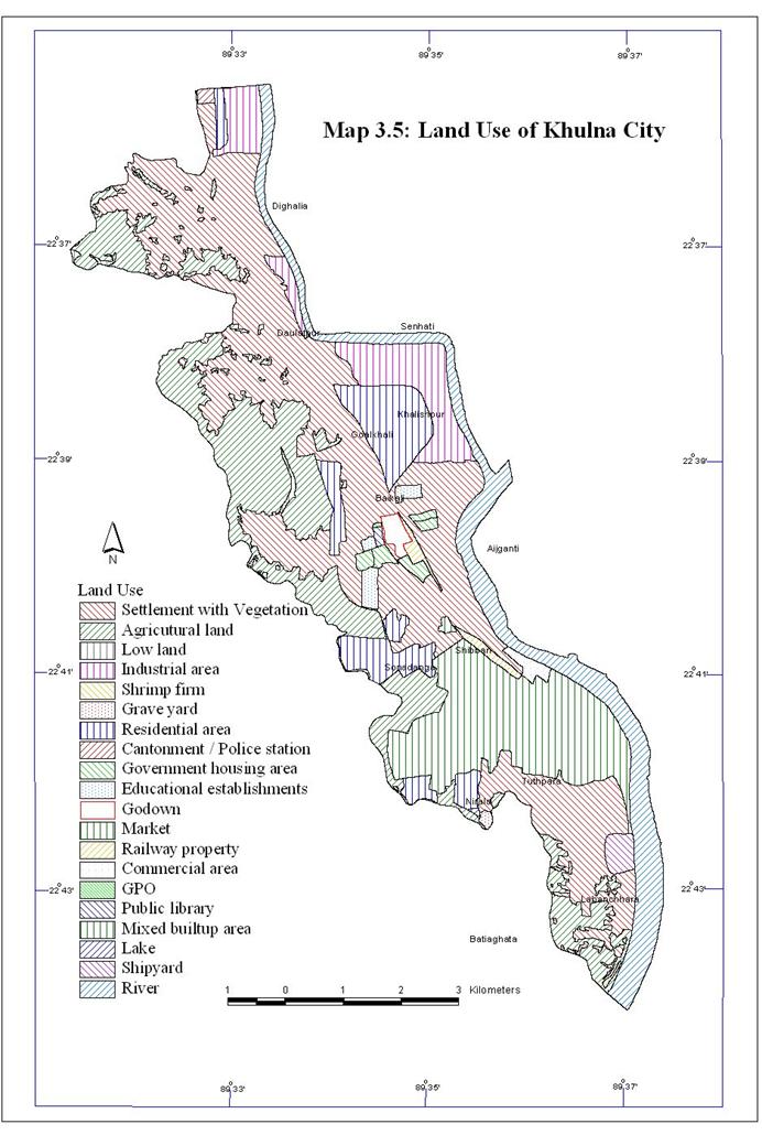
The settlement areas with 23.50 sq. km. (51.1 per cent of the city area) dominate among the land use categories. The mixed built-up area (residential area with intense commercial activity) 14.3 per cent of the total city area, spread over the older areas (ward nos. 20, 21, 23, 26, 27, 19) of the city. It is notable that 21.2 per cent of the city corporation area is in agricultural use, which lies along the western fringe of the city. Table 3.2 and Map 3.5 show the existing land use pattern in Khulna City.

Table 3.2: Existing Land Use Pattern of Khulna City
|
Land Use |
Area in sq km |
Percentage |
|
Settlement Area |
23.50 |
51.1 |
|
Agricultural Land |
9.77 |
21.2 |
|
Mixed Built up Area |
6.58 |
14.3 |
|
Industrial Area |
3.07 |
6.7 |
|
Commercial Area |
0.48 |
1.1 |
|
Education |
0.35 |
0.8 |
|
Railway Property |
0.32 |
0.7 |
|
Shipyard |
0.32 |
0.7 |
|
Government Institutions |
0.13 |
0.3 |
|
Low Land |
0.13 |
0.3 |
|
Grave Yard |
0.07 |
0.1 |
|
Others |
1.28 |
2.8 |
|
Total |
46.00 |
100.0 |
Source: Khulna City Master Plan Project, 1998
Temperature
Remarkable changes in temperature can be found with the changes of seasons in Khulna City. April is the hottest month when monthly maximum temperature is up to 350C. However, Khulna City shows a mild summer than of inland areas, particularly northwestern district, where summer temperature sometimes exceeds 400C. In June, there is sharp fall in temperature due to the outbreaks of monsoon. During the monsoon, the monthly maximum temperature is about 300C. The cool dry winter season begins in November, and January is the coldest month with a minimum monthly temperature of about 100C.
Rainfall
Khulna receives an average rainfall of about 1800mm. The main source of rainfall is the southwestern monsoon. Nearly 81 per cent of total rainfall occurs during June-October. During March-May some rainfall also occurs. Winter is the dry period with little or nearly no rainfall. However, during the months of December and January little rainfall is recorded.
Wind
Due to monsoonal variation of the climate, there are variations in wind direction in Khulna City. The southwesterly monsoon starts from about the middle of March and recedes about the end of September. The monsoon winds blow from the south with sustained force from March to October, The wind blows from the north and northeast in January. February is a calm month with foggy weather in the morning particularly.